Creating custom tiles
The goal of this section will be to show how to create an mbtiles file from Metropolis-2 Data.
At the end we will get a nice Slippy Map that we can
show in BlueSky. Read this MapTiler article
for more information about zoomable maps.

The street data came from OpenStreetMap and was downloaded via OSMnx.
The building data comes from the City of Vienna. Please refer to the building data processeing page of Metropolis-2 for more details.
The geofence locations were chosen with OSM at cemetaries, parks, and other green areas of Vienna.
Finally, the airspace border was selected to be an 8 km radius circle centered in the middle of Vienna.
Note
Check out this cool 3d model of our M2 simulation area. With maptiles by MapTiler and OpenStreetMap.
Note that each dataset may contain information about each individual item. In Metropolis-2 we are interested in seeing which buildings or geofences are intruded by aircraft. Therefore we may want to show that information in BlueSky. The geofence and building data is structured as follows:
fid |
height |
geometry |
|---|---|---|
1 |
250 |
Polygon |
2 |
500 |
Polygon |
The goal will be to show the fid of the individual building when zoomed in.
Creating the tiles with tippecanoe
OpenMapTiles and TileServer GL both work with the mbtiles specification from mapbox.
So we will have to convert our data into this format. QGIS has an algorithm to create vector tiles, however at the
time of this tutorial the vector tiles did not render correctly for the street geometry.
Therefore, we will use tippecanoe from mapbox to generate the tiles.
The first step is to convert all datasets into GeoJSON format.
This can easily be done with QGIS. It is also important to set the coordinate reference system to EPSG:4326.
The four GeoJSON files are saved in the project_data directory.
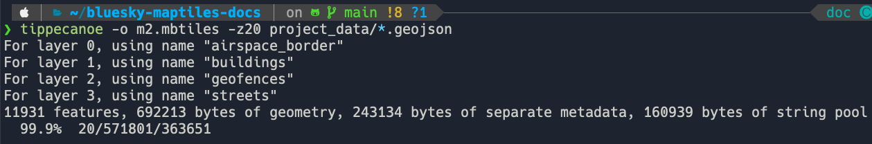
The second step is to create the tiles with the tippecanoe command.
The documentation shows the many different options of the command.
For this tutorial, run the command below from the root directory of bluesky-maptiles-docs
to create m2.mbtiles to zoom level 20.
tippecanoe -o m2.mbtiles -z20 project_data/*.geojson
If it all goes well you should get the following output and the m2.mbtiles ready to go.